-

Volume 1a: Concept Drawings
This document outlines the drawings for exploring initial design ideas.
alarm Published 01 Aug 2013 -

Volume 1a: Geological Drawings
This document highlights the geological surroundings of the Southern Landfill, and the proposed changes as applied for.
alarm Published 01 Aug 2013 -
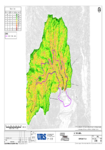
Volume 2b: Geological Drawing
This document provides an image identifying the slope of the landfill, in support of the resource consent.
alarm Published 01 Aug 2013 -
Volume 2a: Air Quality Assessment
This document contains the report of the assessment regarding air quality effect (as part of the evaluation for future waste disposal and the current preferred option) in support of the…
alarm Published 01 Aug 2013 -

Volume 2b: Phase 1 Geotechnical Report
This document reports the geotechnical risks associated with the proposal; as identified by a geotechnical desk study and a preliminary ground investigation.
alarm Published 01 Aug 2013 -
Volume 2b: Geotechnical Report Drawings
This document outlines the fault hazard plan and the slop angles plan in relation to the Geotechnical Report.
alarm Published 01 Aug 2013 -

Volume 2c: Hydrogeology Report
This document outlines the findings of groundwater investigations and assessments of potential effects to groundwater, which is prepared in support of the Southern Landfill resource consent. This report includes details…
alarm Published 01 Aug 2013 -
Volume 2d: Southern Landfill Ecological Assessment
This document reports the overall ecological health of the aquatic and terrestial environments within the proposed Stage 4 landfill extension.
alarm Published 01 Aug 2013 -
Volume 2b: Borehole and Test Pit Log
This document provides a collated table of the boreholes and test pit logs associated with the Southern Landfill area.
alarm Published 01 Aug 2013